Saturday, November 24, 2012

Another Rim Walk and Home


On Monday, October 29th, we drove in to El Tovar for breakfast.  There were still a few spaces in the parking lot.  We got the exact same table we had had our first night, with a view (of a sort) of the Canyon, but this time it was daylight, so we could see what (little) there was to see.  We had some specialty of the hotel--three different kinds of pancake, I think, with a special syrup.  Good.

I went to the lobby and spent a long time getting intermittent Internet access, while Mary Joy went across the parking lot to Hopi House, a Mary Jane Colter-designed southwest Indianish building, used from the beginning as a store selling Indian crafts.  Mary Joy was still there when I went over, and we ended up buying a number of things for gifts, as well as some postcards.


We drove back to Yavapai Lodge and checked out.  Then we drove to the Visitor Center, where we parked and caught the Orange bus to South Kaibab Trailhead.  A number of the people there were going or coming from the (relatively) short,

(relatively) easy hike down to Ooh Aah Point.  Mary Joy talked with some Germans who were about to go down.  Then we talked with a couple (Canadians?) who wanted to know the time and were surprised that their hike down to Cedar Ridge and back had taken only a little over two hours.  We were tempted, but were under time pressure (it was around eleven), so we followed our original plan and walked the Rim Trail back to Mather Point.


This was something of a disappointment, not being as scenic as the hike the day before.  Much of it was through a burnt-out piñon-juniper forest.  In about two hours we were at Mather Point, which has yet another spectacular view.

 From there it was a very short walk to the Visitor Center.  We went in and asked a ranger about our route back to Phoenix.  He suggested the eastern route, via Cameron, but in the end we went back the way we had come.  The scenery is actually somewhat better going on U.S. 180 from the Canyon to Flagstaff than vice-versa.  We wanted to stop for lunch again at La Bellavia, but they were closed, so we went across the street and had chili at the Beaver Street Brewery (also recommended by Lonely Planet) and that was fine.

We got into Phoenix as the sun was setting, and avoided getting tangled in the traffic for a Cardinals football game.  Dinner was at La Parrilla Suiza, a decent Mexican restaurant.

The next day, we went toward downtown for lunch at Christo's, a very good Italian restaurant, where we've eaten a number of times before.  Then we left our car off at Budget, and left the lost camera at the service desk.  Later, however, they found my driving glasses in the car and eventually shipped them to me in Minnesota.  Was there some sort of spell or curse on that car?

We caught our flight, which was uneventful, and got back to MSP sometime after nine o'clock.

To the Abyss and Back


On Sunday, October 28th, we got up early to go to 8:00 mass at El Cristo Rey Chapel, which claims to be the only Catholic Church in a national park in the whole country.

 This is a small one-story building, probably not originally designed as a church, in the residential area, south of the tourist area in Grand Canyon Village.  On the back wall of the sanctuary is a large mural of the Canyon.


The priest, who drives up from Flagstaff, gave a very nice homily, relating his experience with a detached retina to the day's gospel reading about Jesus curing the  blind beggar.   There is no organ or piano, so the only music was a couple of hymns a capella.

We hurried back to Yavapai Lodge, to eat a quick breakfast at the cafeteria there, the Canyon Cafe.   French toast--edible, but not terrific.

Then we drove to Yavapai Point for the 9:30 ranger-led nature walk.  On the walk up from the parking lot we met our docent, Ranger Ron, a burly sixty-year-old with a long, reddish beard, wearing the standard uniform and Smokey Bear hat.  Later, he told us that he had spent most of his life working two jobs, but his wife had always wanted to be a park ranger, so when their son went off to college, so did they.  He said that he loved this job, and intended to do it for as long as he could--he could do it in a motorized wheelchair if he had to.


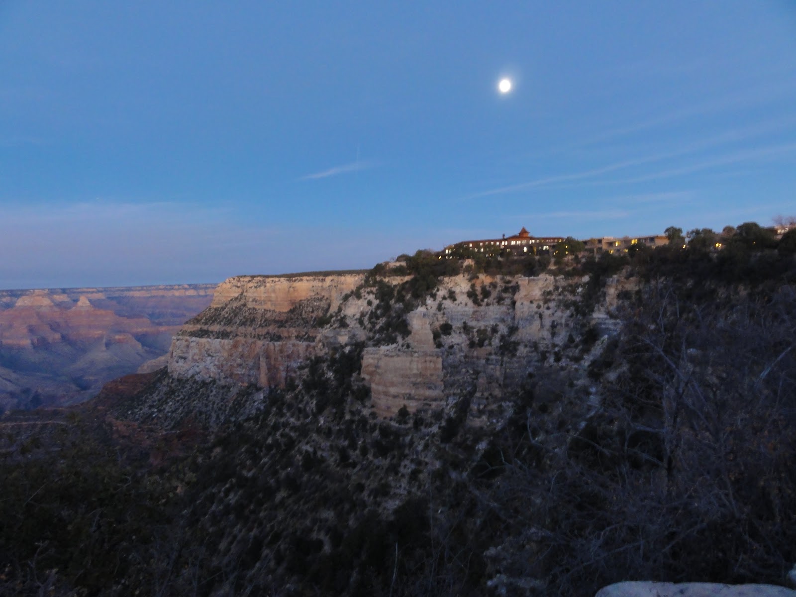
We got started outside the Geological Museum, which was positioned at the viewpoint that scientists had decided was the best to show the Canyon's geological strata.  Someone asked about the glass-floored overlook at the Hualapai Indian Reservation, 250 miles to the west.  Ranger Ron said that he'd let us put our feet up on the windows here, if we wanted.  Normally, this walk was about the plants and animals along the rim, but the ranger decided to take advantage of what was now happening on the North Rim.       For the first time in seven years, conditions were exactly right for doing a "prescribed burn."  He said that there is no such thing as a "controlled burn."  A forest fire is like a child--you can manage it, but you can't control it.  When it has rained enough to soak the trees, but the stuff on the ground has dried out, the Forest Service sets it on fire.  This is to burn off the accumulated dried needles and undergrowth, to prevent large, disastrous fires.  Before the white men arrived, the Indians would constantly set fire to anything that burned.  They knew that fire was necessary to renew the vegetation and that new plants would attract deer and elk for hunting.  Ponderosa pines have fireproof bark and like space (normally, a forest has only twenty per acre).  Ranger Ron said that before we came along and stopped forest fires, a ponderosa pine forest would burn every five years or so, without getting hot enough to harm most of the trees.  We could see the plumes of smoke rising on the North Rim.  The South Rim has more piñon pine-juniper forests--a drier, scrubbier ecosystem, more averse to fire.  It's harder to start burning, but once it does, it gets extremely hot and practically everything is burned up.

We did more listening than walking, but once the hour was over and the group broke up, we continued west along the Trail of Time, a walkway that translated distance into geological time.  It starts out as one large step equalling a year, but eventually each step is equivalent to a million years.  Pictures, diagrams and rock samples point out how  the Canyon's geological strata are laid out.  The Trail is interesting, educational and good exercise at the same time.  We turned around when we got to where the trail to the Shrine of the Ages and Yavapai Lodge split off.  We turned around and went back the 0.7 mile to Yavapai Point, where we looked through the Geological Museum.  There is the half-circle of picture windows that Ranger Ron offered to let us put our feet on.  On the window sill are tethered binoculars, allowing you to make out the Grand Canyon Lodge over on the North Rim, as well as the trees at Phantom Ranch, down at the bottom of the Canyon, and the little black suspension bridge that carries the South Kaibab Trail over the Colorado.


If you turn 180 degrees from the windows, you find yourself looking over a large model of the national park, the way it would appear if you were in a plane high above the Arizona-Utah border, looking south.  The rest of the building is devoted to displays explaining the geology of the Canyon.

We drove back to the Canyon Cafe for lunch (lasagna, I think), then went back to our room for a short rest and to decide what to do next.  We had been pondering the idea of going a short way into the Canyon on the Bright Angel Trail.  Ranger Ron preferred the South Kaibab Trail.  But if we were going to spend three hours on one of these trails (one hour down and two hours back up), we should probably have started earlier.  So, instead, we took the Blue shuttle bus from the Market Plaza into and through the Village, to the Hermit's Rest Transfer stop at the west end of "downtown."

Hermit Road, the road along the rim west of the Village, out to Hermit's Rest, is not open to private automobile traffic during most of the year.  The Park has addressed the horrific summer traffic problem on the South Rim by running free shuttle buses on three round-trip routes.  They built the main Visitor Center, with several large parking lots, two miles east of the Village, at Mather Point.  The Village or Blue Route runs from the Visitor Center through the Village, via the Market Plaza (where you may find the Post Office, the General Store and Yavapai Lodge).  The Kaibab/Rim (Orange) Route goes east from Yavapai Point via the Visitor Center out to the South Kaibab trailhead and Yaki Point.  The Hermit's Rest (Red) Route, the longest, runs the 7.7 miles west from the Village to Hermit's Rest.

 We went about halfway, four miles out to the Abyss overlook.  Needless to say, this is situated above an almost-vertical drop into the depths of the Canyon.  From there, we hiked on the Rim Trail the 2.6 miles back to Maricopa Point, via  Mohave Point, Hopi Point and Powell Point.  This is a very pleasant,

extremely scenic walk, except for the last half mile, from Powell Point to Maricopa Point, which passes around the deserted workings of the Orphan Mine (which mined not orphans, but first gold, then, after World War II, uranium, until the late 1960s).  We had to take a westbound bus from Maricopa Point in order to take the eastbound bus (which has fewer stops) from Powell Point back to the Village.


Once back in our room, I called El Tovar, to see if there would be parking available in their lot for dinner.  They didn't recommend risking it, but suggested instead that we drive to the Shrine of the Ages and take the Blue shuttle bus from there.  Westbound, that would only be one stop farther than "our" Market Plaza stop.  The eastbound route, however is longer and more involved.  Both east and west, however, the Shrine of the Ages is only one stop from El Tovar.  We might have a long wait for the return bus, since by then the schedule would be down to two an hour, but that would be preferable to looking for the C parking lot in the dark again.

So we drove the short distance to the Shrine of the Ages (built originally as a nondenominational church, but now used mostly for various park programs), parked in their lot and waited for the bus.  A short while after we got on, the driver pointed out elk in the woods by the road, then had to stop while a herd of mule deer crossed.  The Shrine of the Ages, Market Plaza and the various buildings of Yavapai Lodge are set in a forest of ponderosa pine.

We got off the bus at the railroad station and climbed the hill to El Tovar.  In the parking lot next to the hotel a car had its headlights on, pointed onto the lawn next to the broad front porch.  Sitting there was a big bull elk.  "Is that real?" asked Mary Joy.  "Its ears moved," I replied.  Otherwise, it was completely motionless, but every so often it flicked its ears.  A man from the car with its lights on was on the sidewalk getting a picture.  Unfortunately, I hadn't brought my camera.  A car stopped in front to let people out.  They were talking in a British accent.  We pointed the elk out to them, and they excitedly called out to the driver, who was starting to drive off, to stop and see.  The elk was unaffected by all this commotion, so we went in to dinner.

This time, instead of being by the windows, we were in the main dining room, by the fireplace.  At a nearby table was a young British couple, on their honeymoon.  I forget what we had for dinner, except that it was good--not great, but good.

They had made some changes to their WiFi, which wasn't working correctly yet, so we weren't able to access the Internet.  We walked over to the Village East bus stop, just as a bus went by in the other direction, so we figured it would be a while before it finished its loop through the Village and got back to us.  It was cold--probably in the low 40s.  Maybe twenty minutes later we got on the bus.  Seated there was a group of four women in full hiking gear, with heavy backpacks and high-powered lamps.  They had just come out of the Canyon, in the dark.  They had spent the previous night in the Canyon, but had been unable to reach the campground, because one of the group had leg cramps, so they had had to camp in the middle of the Bright Angel Trail.  In the middle of the night, someone had come running down the trail, wearing a Batman costume, and had almost stumbled over one of the women in her sleeping bag.  Something as overwhelmingly powerful as the Grand Canyon has strange effects on people.


Sunday, November 4, 2012

Grand Canyon


On Saturday, October 27th, we had breakfast at Chompie’s Deli, a transplanted New York delicatessen-restaurant.  I would be willing to bet that no New York deli has bottles of Tabasco red, Tabasco green and Cholula hot sauce at the tables.  Unfortunately, there was no WiFi there, but we enjoyed our omelets. 
Then we headed north.  We left around 12:30 and drove up I-17, through spectacular desert landscapes, to where it ends, at Flagstaff, arriving around 2:30.  Arizona is a land of pastels: oranges, beiges, yellows, pinks, speckled with green, under a bright blue sky.  Northern New Mexico, on the other hand, struck me as a land of deep browns and greens, while the desert around Las Vegas is a dirty gray. 
In Flagstaff, we found a recommendation, in Lonely Planet’s Southwest United States guide, for a café called La Bellavia.  Lonely Planet continued its perfect batting average as far as restaurants are concerned.  There we had some very good hamburgers. 
We had been climbing all day: Phoenix is at 1200 feet (around 360 meters), while Flagstaff is at 6900 feet (around 2070 meters).  There are three routes from Flagstaff to Grand Canyon Village.  We have never taken the western route, via I-40 due west to Williams, then due north on Arizona 64 to Valle, where the central route (U.S. 180) joins it for the last 28 miles to the Canyon.  If the scenery along the rest of the route is like the joint part, it is a flat, relatively uninteresting plain, dotted with juniper, piñon pine and sagebrush.  The South Rim of the Grand Canyon is, after all, only 100 feet (30 meters) higher than Flagstaff.
The eastern route is the longest and maybe the most scenic.  It passes north through the Painted Desert, on the Navajo Indian reservation, to Cameron, then turns west, along the canyon of the Little Colorado, where there is a tribal park, with an overlook of that canyon and stalls where you can buy Indian crafts.  A park ranger, describing this route to us, said that it illustrates the sort of land that we left the Navajo with: pretty, but not useful for much of anything.  You enter the National Park by the eastern entrance, at Desert View, where there is a tall watchtower designed by the famous Mary Jane Colter, who, as architect for the Santa Fe Railway and park concessionaire the Fred Harvey Company, built most of the park’s more interesting buildings in the 1920s and 1930s.  She is largely responsible for creating the “southwestern” look, based on Native American designs.  After driving along the South Rim for 25 miles, stopping, of course, at all the various overlooks (Grandview Point, Yaki Point, Mather Point, Yavapai Point), you arrive at Grand Canyon Village.  In April 2005, with Mary Joy’s parents, we took this route in the opposite direction, for our return to Phoenix.
But the route that we now take is the one we took going up in 2005, the central one, on U.S. 180, through the volcanic San Francisco Mountains northwest from Flagstaff.  While, as I’ve said, the South Rim of the Grand Canyon is only 100 feet higher than Flagstaff, this very scenic road goes up from 6900 feet to 8046 feet (around 2415 meters), before dropping back down to 7000.  It starts at the foot of Humphreys Peak, the tallest of the San Franciscos, at over 12,000 feet (around 3600 meters), climbing through forests of tall ponderosa pines, then dropping down to the “forest” of scattered, short junipers and piñon pines (gin and pine nuts, anyone?), before joining with Arizona 64 at Valle and turning due north.
It was at this point, between Valle and Tusayan, that we noticed the plume of smoke rising to our north. 
It wasn’t until the next day that we learned what the smoke was about.

We drove through the touristy town of Tusayan, just outside the park. It’s full of hotels, motels, restaurants, fast-food places, souvenir shops and tourist attractions. We went through without stopping, and went straight to Yavapai Lodge, where we were assigned room 7062 in building 4 at Yavapai West. Yavapai West is a 1970s oval of six one-story motel-style buildings, set in the woods, about a half-mile from the South Rim and about a mile east of Grand Canyon Village. The rooms are entered from the outside and you park your car directly in front of your door.

By now, it was late afternoon. We drove into the Village and eventually found parking in Lot C, which is south of the railroad tracks, toward the center of town. We walked up the hill, past the railroad station, by the El Tovar Hotel and Hopi House, and there was the Canyon. If you have never seen the Grand Canyon, I can’t describe it to you, nor can photographs do it justice. It is eleven miles wide, from rim to rim, and a mile deep. Down at the bottom, meandering through the eroded pinkish, brownish buttes (fancifully, called Isis Temple or Brahma Temple or Zoroaster Temple—the nineteenth-century romantic sensibility at work), is the Colorado River, only intermittently visible, if at all, from the rim.

We walked along, checking out the views, going into the Lookout Studio, from the terrace of which are views back to the El Tovar. Then we went on to the Kolb Studio, where brothers Emery and Elsworth Kolb had a photographic studio a century ago. There they developed photos of tourists riding mules into the Canyon down the adjacent Bright Angel Trail and showed the movie of their 1911-1912 trip all the way through the Canyon (around 300 miles). Now there was an art exhibit there, paintings of the Canyon. Nothing that will end up in the Louvre or the Met, but nice.

By the time we finished, it was dark, and time to go to the El Tovar’s restaurant, the best restaurant in the area, where we had a reservation for dinner at 6:15. We sat at a table with a view out the window to the Canyon, if we could see in the dark. Since we couldn’t see in the dark, we had to imagine what the view would look like. I ordered duck in a cherry-merlot sauce, while Mary Joy ordered a pasta dish. However, she didn’t care for it, so after a while we switched and were both pleased with our dinner.

Then we got onto the internet in the hotel lobby (rustic, with deer, elk and moose heads festooning the walls). When we left, there was a herd of mule deer grazing on the grass inside the hotel’s circular driveway. I had a flashlight with me, which was very useful as we walked across the railroad tracks and through the woods to our car.

We got back to Yavapai West in time to see the last three-and-a-half minutes of the Notre Dame-Oklahoma football game, a wonderful upset win for Notre Dame. Three years ago, our October weekend trip was to the Notre Dame-Washington game.  It was an exciting back-and-forth struggle in the rain, with three goal-line stands and Notre Dame winning in overtime after Washington tied the score on a last-second field goal.  We had good seats, high up, opposite the press box, but got rather wet.  I have wondered if video tapes of the game would show, up in the stands, amid the sea of blue Notre Dame Fighting Irish rain ponchos and purple Washington Huskies rain ponchos, a single red dot: Mary Joy's Wisconsin Badgers rain poncho.  This year, when I learned which weekend our October trip would be, I had (only 90% in jest) suggested to Mary Joy that it might be nice to spend that weekend in Norman, Oklahoma.  She was not amused.  In any case, I probably wouldn't have been able to get tickets.  Go, Irish!

And then, to bed.


Friday, November 2, 2012

Phoenix

On Friday, October 26th, we took the 11:19 a.m. Delta flight from MSP to Phoenix. We'd gotten a cheap airfare ($238) and got a relatively cheap (for Phoenix, which soaks tourists with taxes and fees) car rental from Budget, a little black Nissan Versa.

After settling in, we found a coffee shop with WiFi, where we had coffee and e-mail, then took a hike in the Phoenix Mountain Parks, from the parking lot off of 40th Street, south of Shea. The temperature was in the eighties, nearly fifty degrees warmer than back home. The walk was beautiful and very pleasant, going up trail number 8 to a saddle, where there was a stone bench, from which we could watch the sun lowering itself gingerly behind Piestewa Peak. We walked back as the sun was slowly setting, and were surprised to find people just arriving and starting to hike. Curious, Mary Joy asked someone about this. They said that after sunset there was still forty-five minutes of twilight. I assume that Arizonans are used to waiting until the heat of the day is over before they go out and do their hiking. In the summer, when daily average high temperatures are over one hundred degrees, that would be very prudent.


For dinner, we went to Z Tejas, a chain restaurant that had been recommended that day by the barista at the coffee house across the street. It was a big restaurant-sports bar, with a young crowd spilling out onto the terrace. But we got a table inside and had a decent if not terrific meal--Mary Joy had trout amandine; I don't remember what I had. There was live music, a singer-guitarist who was singing Johnny Cash's "Folsom Prison Blues" as we were seated, but later settled into a more folkie vein.

Then back to our apartment, and to bed.